
aNewDomain — Ah, the longitude problem.
It’s dogged sailors ever since they first began cruising the seas.
On land, it’s easy to measure distances using triangulation from reference points such as churches or mountains. But on the sea, sailors spent centuries groping around for a precise method of determining how far west or east from any given point they were.
A compass, after all, only helps you find magnetic north. As for the sextant, t measured how much north or south one was, by measuring the height of the sun or another celestial body.
The Earth, however, turns from west to east so that the east-west position of the sky constantly changes with time. The determination of this ‘length’, that is, the distance to the zero meridian (which today is the one of Greenwich), was long-standing open problem.
Sailors guessed the speed of the ship relative to the water, by dropping ropes into water, but due to ocean currents, a ship could actually go backwards even though it had a reasonable forward velocity relative to the seawater.
The Earth rotates around its axis in 24 hours, so that 1 hour corresponds to a length difference of 360°/24 = 15°.
Thus, if a seaman has a portable watch indicating the time of departure from a port, he would be able to determine his longitude.
However, such a clock did not exist before the end of the 18th century. Large clocks, such as pendulum clocks, were worthless on a pouring sea.
Think about it: If a clock were one minute late per day, that implies a difference of 18 kilometers in longitude on the sea! So, for a sea trip of fourteen days from Europe to America, the error amounts to about 250 km. It would be the 19th century before improvements in seaworthy clocks would finally settle the problem.
In the 17th century, such sea powers as Britain and Spain promised high rewards to anyone who might help them solve the longitude
Belgian astronomer Van Langren responded straightaway. He was fearful of others stealing his work, however, so he decided to dispatch his solution in a coded text.
That code is what I want to talk about in this week’s Pi Guy.
The moon as GPS
Van Langren, or Langrenus in its Latinized version, was baptized in Amsterdam on April 27, 1598, though his parents moved to Flanders and settled in Brussels around 1614.
Until his death in 1675 he worked as cosmographer and mathematician for Filips IV (1605-1665), the then Spanish ruler of Flanders.
And he was the first to make a map of the moon as though it were a world like the earth, with mountains, seas and valleys.
Van Landgren had this idea since the early 1620s when he began to observe the moon through a telescope, but didn’t think of fancy names just for the fun of name-giving.
Van Langren thought that illuminating and darkening certain mountain peaks could serve as a universal clock.s They can be seen simultaeously everywhere where the moon is visible, and so, if one has a precise map of the moon and the time tables of the shadows of moon mountains, one would be able to determine the longitude on the sea.
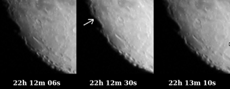
Above: lluminations of moon craters and mountains can serve as a universal clock (photo Jos Pauwels, Antwerp, Belgium).
Through the archduchess Isabella he sent a letter to get a patent for his plan to King Philip IV, the successor of the throne of Philip III and cousin of Isabella.
On May 24, 1629, a positive response to his request followed.
Isabella sent Van Langren to her cousin Filips IV, so that Van Langren could explain his method in Spain.
On July 5, 1631, Van Langren left for the royal court in Madrid, but his request was rejected, twice. The intruiges of the Spanish court were above the poor Flemish scientist’s head. He spent two and a half years in Madrid, until he got broke.
Fortunately, he had another invention up his sleeve: the swim belt, alolowing soldiers to croos a river without the gun powder getting wet. The Markies of Leganes approved it, allowing Van Langren to travel back to Flanders.
Will the truth ever be revealed?
But maybe the Spanish council was right. After all, it’s awfully difficult to make exact time measurements based on shadows on the moon. The light boundary slides slowly over the moon’s surface and is not an shapr line. Moreover, weather conditions often prevent good observation of those shadows.
Jos Pauwels, a mathematician and amateur astronomer from Antwerp, Belgium, tried it out, and his approved the Spanish court’s decision.
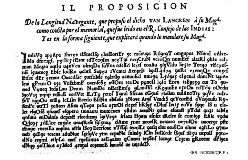
Van Langren must certainly have figured this out himself. But it was not his only method: he wrote he had no less than five ways for determinging the longitude, of which two would work on the sea. He described one of them in a coded form as a special insert in his dissertation ‘La verdadera longitud’ from 1645. Was this the true method of Van Langren?
Some specialists think Van Langren used a so-called ‘double Viginere code’ to scramble his publication. The text may have been written in a kind of old Spanish as is apparent from the introduction and may contain scientific terms with which a decoder may not necessarily be familiar.
As hieroglyphic decoder Jean-François Champollion knows well, the decipher ever awaits its eternal glory.
That fame is best felt here in Belgium, no question. On Van Langren’s first moon map, the spot where Neil Armstrong landed in 1969 is designated as the ‘Mare Belgicum.’
That same day marked a Belgian national holiday. It also happened to be the day when Belgian cyclist Eddy Merckx won his first Tour de France. And that’s how I’m sure no Belgian will ever forget the life and accomplishments of Van Langren, brilliant codes notwithstanding.
For aNewDomain, I’m Dirk Huylenbrouck.