
aNewDomain.net — A beautiful warm, sunny summer day this winter at Del Valle Regional Park, Livermore, CA. Twenty-five members of the San Ramon Trailblazers hiking club are assembled in preparation for a 4.5 mile hike through the park. Some of them have an app called Map My Hike on their smartphones. Of the six who do have the app on our hike, four have it on their Apple iPhones and two are using it on Android. The result is pretty intriguing — and a not-too-flattering Map My Hike review, as you’ll see below.
The trouble starts on the first hike.
Carol tries to download the app to her Apple iPhone, but the signal isn’t strong enough in this remote area. She does have a pedometer, though. That will come in handy.
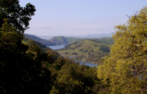
Image credit: EveryTrail.com
Of the six with the app, three have AT&T as their carrier, two have Verizon, and one has Sprint. The Sprint-ish hiker is using Map My Hike Plus, for which she actually paid. Basic Map My Hike is free, she explains, but now she may ditch the paid version for the free, she tells me. She says the free version is more accurate.
And she also plans to switch from Sprint to one of the larger carriers.
The hike is extended slightly by a small side trip, making for a total of approximately 5 miles. At hike’s end, it’s time to take stock.
Judy has a Verizon-based iPhone 5, which she hasn’t upgraded to the newest version of Apple iOS because she doesn’t like the icons. Another big issue for her is the iPhone battery. She says that it’s good for about 7 miles. A case with an auxiliary battery is available, she says, but that adds weight to the phone.

Image credit: EveryTrail.com
She hikes, at most, twice a week and indicates that her 4GB data plan is adequate, too. As for Map My Hike? For Judy, the app is showing an elapsed time of 2:24 and a distance of 4.89 miles.
Also with Verizon is Vicki, on a Droid phone. She’s fortunate to have bought her plan far enough back that she has unlimited data. The Android version of Map My Hike is reading 2:30 and 4.88 miles.
Something’s wrong.
Carrying a Samsung Galaxy with AT&T as the carrier is the hike leader, Nido.
Image credit: EveryTrail.com
He jokes that his smartphone is always right while other smartphones are off. Map My Hike is showing 2:28 and 4.52 miles for him.
AT&T is also the carrier for Charlene and the other Judy hiking with us, both of whom have the app on Apple iPhones. Their respective readings are 2:28/5:29 and 2.23/5.3.
Times are all fairly close; distances range from 4.52 to 5.3 miles.
Carol’s pedometer reading is 4.3 by the way.
But Liz, with a Sprint-based iPhone shows readings of :36 and 3.65.
She says she plans to try it in her neighborhood where she knows the mileage and there is Sprint coverage.
What accounts for the discrepancies in my little sample? It could be any number of factors, ranging from platform to carrier — to setup to sunspots. What gives?
Now, the company behind the app is MapMyFitness, based in Austin. Founded in 2007, it offers fitness-oriented websites and associated mobile GPS applications including MapMyRun.com, MapMyRide.com, MapMyWalk.com, MapMyHike.com, MapMyFitness.com, MapMyMountain.com, and MapMyTri.com.
As for Map My Hike, another try was definitely in order.
So — on the second hike two days later — and with a smaller group of people — things are weird again.
Ron, with AT&T, gets 7.1 miles from Map My Hike. But his non-GPS Fitbit shows 6.7.
Liz the Sprinter has a reading of 5.4 miles. Lisa clocks the highest number: 7.8.
Online Map My Hike reviews of the app are mixed, I should point out.
And Map My Hike reviews vary within our group, too.
“I really like my app,” says Vicky. “It is easy to use, and I enjoy the audio ability because it allows me to hike hands-free without having to constantly pull out my phone for updated information.”
After trying her neighborhood walk experiment, Liz reports “I did try Map My Hike walking around my neighborhood, and it was spot on. I had two orange bars, so I think the issue is that I’m not getting good GPS reception on the trail. So the app is pretty worthless for me!”
And so Lisa contacts MapMyFitness, and this is where things get really interesting. Lisa writes to the appmaker:
The Map My Walk app records greater mileage than I am actually walking. I know this because several others use an app and also there are mileage markers on several trails. It records almost two tenths of a mile more per mile. Is there any way to make it more accurate? Thank you.”
And here’s how Map My Fitness, maker of Map My Hike, responds:
Our apologies for any recording issues! Occasionally a lapse in signal or other factors can cause this sort of thing to happen. The troubleshooting tips outlined in the article below should resolve most problems with the app including incorrect recorded distance, stats tracking, and audio feedback. The app is not intended to calculate distance or other stats when using on iPods/iPads/tablets or other non-GPS devices, or when recording an indoor, non-GPS activity type. Please let us know if you experience any further issues after completing the troubleshooting steps in the following articles.”
And then the rep adds:
If we fixed your issue or provided a proper explanation, your support request will not require an update and will close automatically after three business days without your response. If your issue requires a fresh set of developer eyes it could take a little while to diagnose and solve, but if you email us from the link above we can provide an update. Regardless, we thank you for your patience, feedback, and assistance in crafting the best fitness tracker on the market.”
Lisa points out that, in our collective experience, Map My Hike’s accuracy and consistency are not great. She said, “We were out on the trail almost three hours, and my battery, which started at 100 percent, had 43 percent left at the end of the hike. I bought a car charger for Christmas because the app uses a lot of the battery.”
She continues with, “If I’m not going straight home, I always need to charge my phone to make it through the day. For the basics, the app is easy to use. I just wish it were accurate.”
We’ll be following up with the Austin-based Map My Hike people based on the conclusions we made in this ambling Map My Hike review. But from the looks of it, one thing is clear already.
Austin, we have a problem.
For aNewDomain.net, I’m John Barry.
John Barry is a senior contributor here at aNewDomain.net. The founder of trACTION painting, John has coined such terms as: baint and skaint, referring to painting with a bicycle’s tires or painting with a rollerskate’s wheels, respectively. Read all of John’s stories on aNewDomain.net by clicking this link: here.